
Africa is still a continent where geothermal energy opportunities remain unknown or ill developed. There is no specific geothermal system in Africa, and it is of use to precise the various possible options. The Geothermal Atlas for Africa (GAA) project, developed under LEAP-RE Pillar 2 aims to map geothermal resources for the development of African electricity production and for water use applications.
In this perspective, Géo2D, one of the GAA project partners, proposed to distinguish 10 geothermal play-types based on the geodynamic environments encountered in Africa:
- Eastern branch of the East African Rift System;
- Red-Sea and Gulf of Aden including Afar;
- Western branch of the East African Rift System and Southern Rifts;
- Deep reservoirs from sedimentary basins;
- North Africa (Mediterranean collision zone);
- Oceanic and continental mantle plumes (Comoros, Cap Verde, Darfur);
- Oceanic fracture zones off-shore & on land (Cameroon line);
- Hot-springs & heat anomalies from basement discontinuities;
- Deep EGS;
- Ground Heat Pumps (12-24°C average).
Each play-type determines a specific geothermal conceptual model and also allows for specific geothermal application, with rather different economic characteristics. The exploration strategy also differs, as well as the development and technology to be considered.
Data Collection and Analysis
Since UNIFI organized the WP9 “Geothermal Atlas for Africa” first meeting on September 3 2021. where GAA partners had the opportunity to introduce themselves to each other for the first time, a lot of work has been happening to define the origin and location of low to high enthalpy geothermal resources for the development of African electricity production.
Land Surface Temperature (LST) is used as an indicator of the thermal information associated with faults or volcanic systems and as a key factor in obtaining surface heat fluxes. The highest recorded subsurface formation temperature is 95 ͦC and heat flow up to 122 mW/m2. In this area (Djibouti, Ethiopia, and Kenya), the use of auxiliary chemical geothermometers applied to waters for geothermal exploration has been investigated. In the Mayotte Island, Gas sampling geothermal exploration was carried out.
Special attention has been devoted to Djibouti Republic area, by (i) assembling scattered data, (ii) listing all the bibliography related to geothermal energy, (iii) digitalizing the useful data and (iv) filling the gap with a new method and reinterpretation of the previous studies. These data were classified based on the relevant objectives of GAA project.
In recent months, an inventory of central part for thermal springs in northern Algeria has been realized by the means of Field Works campaign, measurements of physical-chemical parameters of the main thermal emergences, analysis of the geological outcrops, geological synthesis of the thermal springs studied. Finally, some thematic maps were realized.
The efficient and sustainable use of the geothermal resources for power and heat/chilling services is the main goal of the Engineering Task 9.2 of GAA. In the early months, a preliminary study was carried out at regional level of the East African Rift countries (EARs) on the distribution of available geothermal resources from IRENA atlas. Thus, all these resources were primarily ranked based on the temperature level. In addition, local maps were built to depict the distribution within some countries of EARs based on the distribution of population density and electricity consumption.
This initial activity focused on high enthalpy resources and their use for electricity production by a first level simplified model, based on the fundamental thermodynamic characteristics of the assessed geothermal resources (e.g. temperature, pressure and flow rate). It provides a preliminary sizing of suitable configurations of geothermal powerplants by minimizing the economic and environmental costs. With about 500 different conditions on input variables, it builds a representative metamodel, which provides a tool for the preliminary sizing of a possible power plant. These variables include economic correlations of mechanical components and environmental indicators, the latter determined through LCA.
Socio-Economic Aspects
The socio-economic aspects related to the geothermal energy in African countries is another pillar of GAA: this information will be integrated with the Geothermal Atlas for Africa, with the objective of maximizing the benefits for local population. The first step undertaken was the analysis of the state of the art, realized by two different actions. (1) Socio-economic analysis,based on existing documents available at national scale from national and international databases by reviewing socio-economic context for renewable energy development in Africa (energy balance in Africa, drivers of energy transition; political economy of energy transitions/gainers and losers, etc.). (2) Analysis of cases of renewable energy development across Africa, focused on: (i) identifying cases of geothermal and potentially renewable, considering the scarcity of geothermal experiences in the African continent; (ii) energy developments to provide a collection of good practices implemented by various actors in order to understand drivers for success and barriers (e.g. cultural-based drivers or barriers, drivers for communities’ engagement, regulatory barriers, etc.).
Maps of Structural and Geological Data
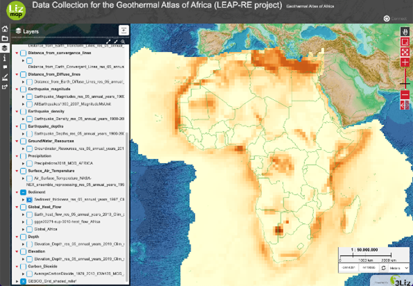
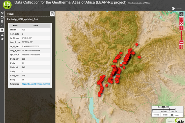
Among the main initial steps contributing to the realization of Geothermal Atlas of Africa (GAA, Task 9.4) there are the maps of structural and geological data. The first application, based on local and continental scale Earth sciences data, is referred to the Main Ethiopian Rift (MER).
For the MER, the following datasets were organised and collected: i) faults; ii) caldera rims; iii) volcanic vents; iv) fault-slip data; v) rock dating; vi) geolocation of the papers from which dataset were collected. The following continental-scale datasets were prepared: i) geothermal power plants; ii) distances from the different plate margins; iii) earthquake density, magnitude and depth; iv) groundwater resources; v) rain precipitations; vi) surface air temperature; vii) sediment thickness; viii) global surface heat flow; ix) elevation; x) carbon dioxide emissions; xi) geothermal power plant suitability map.
")

