
RE4AFAGRI and World Resources Institute (WRI), a global research organization that has been working in Africa for more than 30 years, supporting local partners and Africa governments to advance forest protection, landscape restoration and sustainable cities, are organizing capacity building activities to support African researchers, analysts and policy makers on a range of topics relating to the water-energy-land nexus and rural development.
The first week-long capacity building activities will be held in Addis Ababa, 16-20th October 2023 and will convene approximately 30 participants from across sub-Saharan Africa. The week consists of two workshops. The first will be an introduction to tools, assessment and policy analysis of the water-energy-land nexus in SSA and the other an advanced course on WEL-nexus modelling tools.
WRI selected data platforms and models (for these Workshops)
- Energy Access Explorer is an online, open-source, interactive geospatial platform that enables clean energy entrepreneurs, energy planners, donors, and development-oriented institutions to identify high-priority areas for energy access interventions. More details
- Aqueduct is an online,interactive geospatial platform used to identify and evaluate water risks. More specifically, Aqueduct Water Risk Atlas is used to understand water-related risks and assess exposure to water risk across multiple locations. More details
- Agriadapt (the Agricultural Adaptation Tool) is an online, interactive geospatial platform that helps agricultural businesses assess how climate change is impacting agriculture. More details
RE4AGARI models
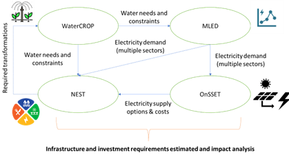
- WaterCROP is an evapotranspiration model to estimate the crop water demand by source (rainfall plus irrigation) as a function of the soil moisture available in the soil and the potential for irrigation expansion. More details
- M-LED is a Multi-sectoral Latent Electricity Demand geospatial data processing platform to estimate electricity demand in communities that live in energy poverty. More details
- OnSSET (the Open Source Spatial Electrification Tool) is a GIS based optimization tool that has been developed to support electrification planning and decision making for the achievement of energy access goals in currently unserved locations. More details
- NEST (The NExus Solutions Tool) is a modeling platform that integrates multi-scale energy–water–land resource optimization with distributed hydrological modeling, providing insights into the vulnerability of water, energy and land resources. More details
Notes on application and participation
- Attendance at the workshops will be free for participants. Due to limited places, participation in the workshops will be subject to an application process for both events to determine suitability.
- Applicants seeking to participate in Workshop #2 must also participate in Workshop #1.
- Sponsored bursaries to cover travel and accommodation costs will be available for some participants and will be evaluated as part of the application process.
For more information and queries, please contact Edward Byers byers@iiasa.ac.at and Dimitrios Mentis dimitrios.mentis@wri.org
")

